Yesterday, Kottke shared this article from Earthly Mission, about how Hitler, Stalin, Freud, Trotsky, and Franz Joseph all lived within a short distance of each other in 1913-1914. No disrespect to the author of that article, but my internet-sense started tingling.
Something about that map seemed off. I Googled the premise and found this article in BBC from 2013.1The locations on the map of where each person lived look nothing like the ones in the Earthly Mission post. Not only that, but because the map was zoomed in, most figures had arrows pointing miles away from the map’s edges.
“What a lousy job,” I thought. And so began my journey to set things right.
Too bored to read the rest? Go straight to the map.
First, I went to Wikimedia Commons and found old maps of Vienna from around that period. Because of course there is a specific category with hundreds of historical maps of Vienna. The closest in time I could find was this one from 1910.

I downloaded it in its glorious 4,426×4,390 resolution and with the map inside Photoshop on one screen, and Google on the other, I started placing the dots.
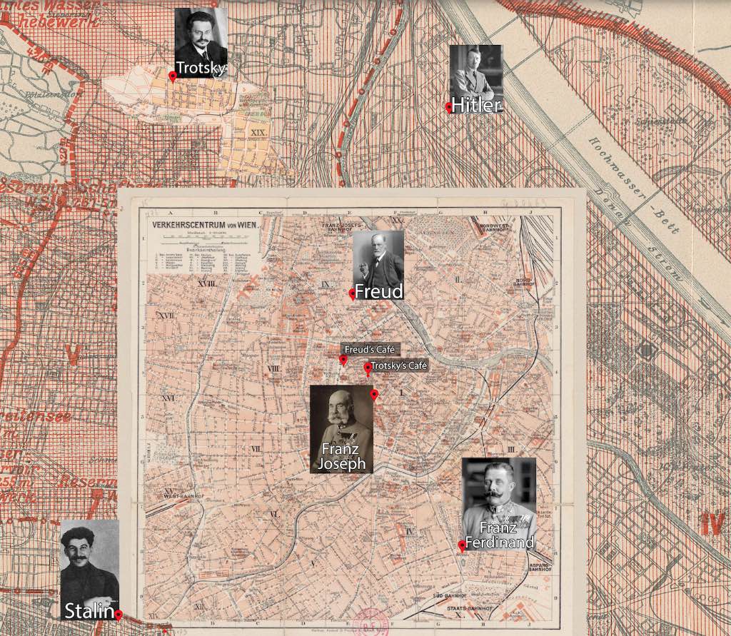
First was Sigmund Freud, at Berggasse 19, the address where he “lived and worked for 47 years before he had to flee from the Nazis in 1938” as the Freud-Museum website puts it in its landing page. Then there’s also the Café Landtmann, at Universitätsring 4 where Freud often had his coffee.
Emperor Franz Joseph resided in the Imperial Apartments of what is currently a part of the Sisi Museum. His nephew Franz Ferdinand, who was soon to be assassinated, lived at the Belvedere Palace a mere 30-minute walk away.2
Café Central, Trotsky’s favorite coffee shop, was located at Herrengasse 14, just a few blocks away from Freud’s regular spot.
But the edges of the map caught up with me. Hitler and Stalin were out of bounds (this time literally). 3
So I opened Wikimedia Commons once again, and found another map, from 1902 that included the broader area.

Unfortunately this map was way less detailed, so I decided to superimpose the 1910 map on top of it. Since I didn’t want to shrink the original map, I expanded the second map to a resolution of 10 000 x 10 000, zooming in until everyone’s residence was visible.
In 1907, Hitler moved to Stumpergasse 31 in Vienna, in hopes of studying at the Academy of Fine Arts. A couple of failed attempts later, and after his mother’s death, he found himself in a homeless shelter at at 27 Meldemannstraße in 1909. He stayed there up until May of 1913, trying to make a name for himself in the arts world. It makes you wonder how different the world would be today if he had been even slightly more talented as an artist.
Between January and February of 1913, Stalin took a field trip to Vienna using a forged passport under the name of “Stavros Papadopoulos”. He went there at the request of Lenin to investigate the interaction with the most diverse peoples in the multi-ethnic state of the Danube Monarchy4. He stayed with a Russian emigrant couple, Alexander Antonovich and Yelena R. Trojanovsky on Schönbrunner Schloßstraße 30.
Trotsky moved to Vienna in October 1907 and lived there until August 1914. In 1913, he lived at Rodlergasse 25.
And here begins my second parenthesis. Rodlergasse, located in the northwestern part of the city and outside the boundaries of the original map, did not yet exist when the 1902 map was produced. I had to return to Wikimedia Commons, where I found the 1928 map below. I only used a small section of it and pasted it on top of the 1902 map.

The BBC article also includes Tito in the title, placing him in Vienna in 1913. This is just sensationalism; Tito was actually working at a factory in Wiener Neustadt, a town nearly 40 miles away.
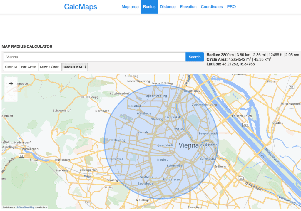
Now that I have my map with my places marked, what’s next? I searched for websites that could compute the smallest enclosing circle given points on a map. Spoiler alert: apparently there aren’t any5.
Next best thing was CalcMaps. I set a point in the middle of Vienna, and tried meticulously to include every point of interest within the smallest possible radius. I got them all inside a circle with a radius of 3.8km or 2.36mi. The outer points being the residences of Trotsky, Hitler, and Stalin.
And after all this talk, you can find the zoomable map below:
You can also download a humongous 184mb .png of it here: